March 11, 2021, marks the 10th anniversary of the 2011 Tohoku earthquake and tsunami and is a good time to prepare for a tsunami on the Pacific Northwest Coast
The coasts of Oregon, Washington, and Northern California are exposed to tsunamis from distant earthquakes, such as the March 11, 2011 Tohoku Japan event, which killed more than 15,000 people. However, the greatest risk to Northwest coastal communities is from a very large locally generated tsunami produced by an earthquake (magnitude 8-9+) occurring immediately offshore the Pacific Northwest coast on the Cascadia Subduction Zone.
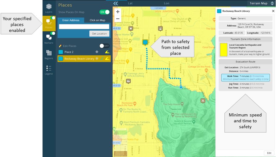
A new online feature in the Northwest Association of Networked Ocean Observing Systems (NANOOS) Visualization System (NVS) Tsunami Evacuation Zones viewer now integrates those results by providing a custom map view showing your quickest street route to safety outside the tsunami zone after a local Cascadia earthquake. The tool also shows the distance to safety and how fast you need to travel to escape the tsunami.
“Knowing the specific path you need to take to reach the high ground quickly will help coastal residents and visitors plan well in advance before an earthquake and tsunami occur,” says Jon Allan, Oregon Department of Geology and Mineral Industries Coastal Geomorphologist. “With this information, you can practice your route, whether from your home, school, or work. Every minute will count after a local earthquake.”
This initial rollout of the tool is for the communities of Seaside, Rockaway Beach, Pacific City, and Coos Bay. Users who create free NANOOS accounts can save their markers and paths for later reference.
Over the past year, the Oregon Department of Geology and Mineral Industries (DOGAMI) has collaborated with the University of Oregon InfoGraphics Lab and GIS Mapping Program to convert tsunami evacuation modeling results for these four pilot communities, in order to build a tsunami routable road network that would allow users to determine the best route out of the tsunami zone automatically via a web-based portal. Paths to safety for all Oregon coastal communities are being developed and will be added when available.
NANOOS NVS Tsunami Evacuation Zones users can also print out tsunami hazard zone maps for their areas, and use the app on smartphones. The path to safety functionality is being developed to display on both the custom printable maps and smartphones.
The path to safety feature is the latest addition to the NANOOS NVS suite of tools for exploring ocean data on the Oregon and Washington coasts and was developed by the University of Oregon (UO), Department of Geography InfoGraphics Lab, UO GIS Mapping Program, NANOOS, and DOGAMI, with funding by the National Oceanic and Atmospheric Administration (NOAA). The data used to develop the routes are derived from “Beat The Wave” tsunami evacuation studies undertaken by DOGAMI over the past several years in order to evaluate potential barriers to evacuation, minimum travel speeds, core evacuation routes, and even tsunami vertical evacuation sites.
- The Tsunami Evacuation Zones viewer can be found on the web at: http://nvs.nanoos.org/tsunami.
The free smartphone app, NVS Tsunami Evacuation, is available from the iTunes App Store and Android Market: